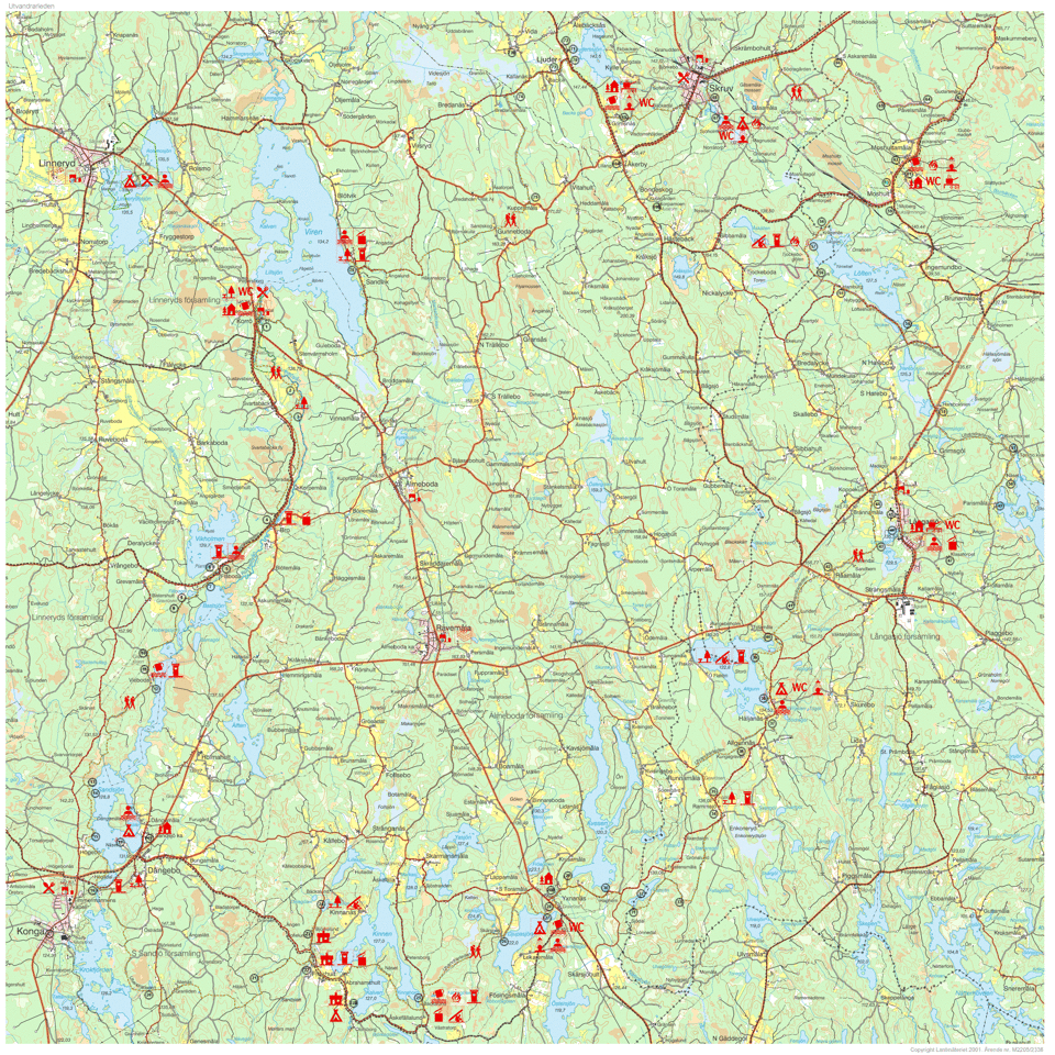
Map and route description of the emigrant trail
Route description
1. Korrö Vandrarhem, Linneryd, tel +46 (0)470-34249
Korrö is an old craft village in which Ronnebyån River has provided power for a number of trades such as a flourmill and sawmill since the 16th century. The trail runs south through Korrö Nature Reserve and continues along Ronnebyån River.
Homepage: www.korro.se
2. The embankment on which you walk is a barrage against the spring and autumn floods in Ronnebyån, a so-called embankment with a system of canals connected to a (3.) pumping plant that drains approx 40 hectares of farmland. The work was carried out by hand and spade between 1939-1944.
4. The Village of Bro with a waterfall in Ronnebyån River had three river mills and two grass mills already in 1580. The latter were probably small watermills. See the sign.
5. Lake Vikholmen.
6. Modern nursery. 8 million Norwegian spruce, Scotch pine and birch tree forest plants are produced here every year.
7. Flåboda Hill with stone circle (500 BC–AD 500). The hill has been used to store timber and pulpwood, which were floated to the sawmill and pulpmill in Konga. The floating stopped in the 40s.
8. Here the trail continues along an old route alongside and on a (9.) gravel ridge where several big barrows (R) have been preserved.
10. Barrow with stone cist at the bottom dating from 1500-500 BC. Individual finds show that the district was inhabited as far back as 5000 years ago.
11. Barrow.
12. Vieboda. Toilets.
13. Building foundations, Högebomåla. In 1836 when Södra Sandsjö Church was consecrated by Bishop Esias Tegnér, the owner at the time, Lars Persson, received a medal from the Agricultural Academy for his new design of a corn-drying box. The whole property is now overgrown by forest.
14. Resting place by Sandsjön. Garbage can.
15. The wolf pit, a pitfall set with stones, very well preserved.
16. Dångs Bridge, old arched stone road bridge built in the
1840s.
17. Shop in the gas station. 500 meters to the food service and Örmobadet with a swimming pool during June-August..
18. Näset, Dångebo (2 km) campsite with swimming and shower facilities.
19. Sjöviksgården Vandrarhem & Hotell, Dångebo,
tel +46 (0)477-16600. 2 km.
Homepage: www.sjoviksgarden.se
Södra Sandsjö Church Village, church.
20. Corduroy road. Here the trail crosses the marsh on a corduroy road, i.e., a road of round timber laid lengthwise and crosswise and probably on a brush mat. The bridge was built in 1918-1919 for horse-drawn carts transporting timber and pulpwood to Gamle Sawmill by Krokfjorden and to Konga Pulpmill, now closed down.
21. Klostergrottan is a geological sight of interest. Excavation finds have shown that it was inhabited during the Stone Age.
22. Abrahamhults Loge. Sleeping accommodation in rooms and cottages with kitchenette. Shower and WC. Camping
facilities.
Abrahamshult Danecamp AB
Tel +45 4043 6498 alt. +45 4041 0031
Homepage: www.danecamp.dk
23. Kulagölen (1.5 km) game fishing waters, fishing permit required, wind shelter.
24. Åskefällalund, wind shelter by the shore of Kinnen, fireplace, toilet.
25. Skärsnäs Village. From Åskefällalund to Skärsnäs the path runs over previously cultivated land. Old hayfields, croft fields and moss plantations are evidence of cultivation. The now overgrown canal in Skärsnäs was dug and blasted in 1893. The canal diggers were paid one Swedish crown per day and the total cost was 2000 Swedish crowns.
26. Djupasjön, municipal swimming and campsite, water, toilet.
27. Yxnanäs Ancient Cottage next to the main road and Yxnanäs School. It is home to Yxnanäs's local folklore society's museum. Call Leif Jonsson tel. +46 (0)477 - 660 59.
28. Holken, Yxnanäs, overnight accommodation,
Tel +46 (0)477-164 11, 660 85. Breakfast can be booked in advance.
29. Bauta stones and stone cist (0,5 km).
30. Eel fishing, "Ålavärmen" has been owned by "Yxnanäs Byamän" from time immemorial according to an old judgement. The fishing is jointly owned and used in a certain order of priority.
31. Provincial boundary between Småland and Blekinge, parish boundary Älmeboda-Långasjö through the border brook and Flatsjön. South of the lake the terrain has large boulders and a "perched block" on a rock.
32. Flatsjön. This area was a border district between Sweden and Denmark until 1568. The coniferous forest area is known as "Ulvamon" ("ulv" means wolf).
33. Tenement soldier's cottage, the large coarse-grained boulders on this part of the trail are known as "Blekinge granite" and those with finer grain "Växjö granite".
34. Rammsjö Village, the word "Ramm" in Rammsjö originates from ram=raven. This village has eight-cornered houses east of the road. There is a resting place with toilet, and a logbook in which you can write your name.
35. Barrows, next to the road towards Runnamåla, dating from the late Stone Age or the Bronze Age.
36. Allgunnås Västergård. According to legend, a king is buried in one of the barrows east of the path.
37. Häljanäs, the name is derived from the Swedish "helig" and "näs" and may mean holy place. This has probably been a pagan place of sacrifice.
38. Häljanäs swimming, with toilet, shower, open-air swimming and camping facilities. Opening times 10/6-15/9. The facilities belong to the Municipality of Emmaboda.
39. Campsite and toilet, nice views over Lake Flaken.
40. 41.Dalen and Lunden, two former 19th-century crofter's holdings bound to day-work at Totamåla Farm.
42. Råamåla Village. The scene from The Emigrants depicting the "departure from Korpamoen to Åkerby Junction" was filmed on the small forest road with all the gates.
43. Sjökullen. Långasjö Church and the lowered Långasjön Lake are visible from the hill. The northern part was restored in the 1980s.
44. Koppekull, has a farmhouse in "America-inspired style". A returning son from the USA had it built. He had the old 18th century farmhouse demolished and built a new dwelling house there.
45. Långasjö Church Village. The trail runs through the old part of the church village on the way to author Gertrud Lilja's childhood home. Near the big greenhouse there is a museum in an old barn called Galleri Garvaregården. The smaller house next to it is an old tannery building. The church village has provisions and overnight accommodation. Fishing and swimming in Lake Långasjö. Fishing permits are sold at the hostel.
46. Långasjö Vandrarhem, tel. +46 (0)471-50310, 070-3644482, is housed in the converted church stables and has41 beds. One stable has been set out as a "rest hostel" with toilet and electric hotplate for hikers..
E-mail: sovaistall@50310.se
Homepage: www.sovaistall.50310.se
47. Klasatorpet. Signposts to "Klasatorpet" where The Emigrants was filmed. The cottages have been preserved in their original state as at the time of filming.
49. Parismåla. From here you can catch a glimpse of Lake Törn.
50. Näset. Här kommer Petter was filmed here by "Näset".
51. Törsbo Mill.
53. Harebokvarn, here the trail continues along a beautiful gravel ridge.
54. Salebodaåsen, is part of a gravel ridge south of Lake Löften.
55. Hamburg, the farm grounds, buildings and fences are managed in an old traditional way.
56. Lake Löften.
57. Resting place with toilet and wind shelter.
58. Kråkenäs, there are two enormous erratic blocks from the ice age here.
59. Modala Glassworks. The path now continues into "Mobergsbygden" (the Moberg district) with obvious reminders of Vilhelm Moberg's time. Two hundred metres from the junction towards Emmaboda are the remains of Modala Glassworks where Vilhelm Moberg worked when he was young.
60. Pestkyrkogården (The Plague Cemetery). At the start of the 18th century the population was hit by the plague and this cemetery was built. 70 people are said to be buried here.
61. Moshults Vandrarhem, Emmaboda, tel. +46 (0)471-45012, +46 (0)70-2969353. Rooms for hire with breakfast or self-catering, mini-kiosk, nick-nack shop, cycle hire. The hostel is located 185 m above sea level with stunning views.
Homepage: www.moshultsvandrarhem.com
62. Moshultamåla Old School. The schoolhouse to which Vilhelm Moberg went was moved from Påvelsmåla to its current location in the beginning of the 1960s. It has books and other objects from Moberg's life. Outside the schoolhouse is a bust of Vilhelm Moberg erected in 2000.
Seasonal opening times, tel +46 (0)471-450 12.
63. Memorial to Vilhelm Moberg. The location where the author's childhood home –tenement soldier's cottage No 132 – once stood.
64. Påvelsmåla, the school village in Vilhelm Moberg's
childhood setting.
65. Påvelsmåla School, the original location of the school were Vilhelm Moberg learnt to read and write.
66. S. Askaremåla, natural Småland agricultural environment.
In the community of Skruv you can stock up on provisions, visit sights, swim, fish, etc.
Skrufs Glasbruk
Characterized by timeless and stylish handmade glass. Open to visitors all year round.
Homepage: www.skrufsglasbruk.se
Glass Museum
The local folklore society displays glass from Skruf Glassworks, all epochs from 1897 to the present day. Open during the summer.
Tractor Museum
Open by arrangement. Tel. +46 (0)478-201 26.
67. Skruv swimming Badsjön. Sports ground and adjacent fishing lake Toilet, open-air swimming and camping. Laxsjön is stocked with rainbow trout. Fishing permits can be purchased at Skruv's kiosk, tel +46 (0)478-200 04.
68. Åbro Kvarn, Skruv A small brook runs next to Skruv's swimming, and according to Vilhelm Moberg it was here that Robert, the farmhand in The Emigrants, played and lost his hat. Sign for place to swim.
69. Grimsnäs Herrgård, Ljuder, Skruv, tel. + 46 (0)478-204 00. Bed & Breakfast, hostel and restaurant. Scenic location in the middle of a beautiful oak forest
Homepage: www.grimsnas.se
69A. Åkerby Junction This is the starting place of Vilhelm Moberg's emigration epic. There is a memorial with a map and inscriptions here. The junction is a quiet resting place with all the things pertaining to an old junction such as signposts, milestone, bridge stones, gates, stiles, fences and a meadow full of flowers.
69B. Korpamoen & Bondeskog 2.5 km south of Åkerby. Vilhelm Moberg indicated that this was the intended location of Karl Oskar and Kristina's home in Ljuder. Rest hostel with toilet and barbecue facilities by Skogslund, 1 km east of Korpamoen.
70. The church stables in Ljuder The church stables next to Ljuder Church are in their original state.
71. Ljuder Church The church in the Emigration District was built in the 1840s with huge sacrifices from the poor Ljuder inhabitants. The church setting and surroundings are of great culture-historical value as an example of a Småland parish centre. It is part of the County of Kronoberg's preservation of ancient monuments programm. Gröna vägen between Åkerby Junction and Lessebo, a scenic, winding road popular with cyclists and motorcyclists.
72. The parish hall in Ljuder with the community centre, museum and America Room. There are many fine collections of whole homes and information on the emigration to America here. The parish hall has an emigrant room on display.
Contacts: Börje Nilsson tel +46 (0)478-230 24
Coffee is served in the cottage during the summer.
73. Backa. Notice the beautiful juniper hill and flax shed.
73B. Vida Village, old-fashioned features and house names. Ateljé Vidagård, handicraft, arts and crafts, farm shop and café. Open Tuesday-Sunday
Homepage: www.ateljevidagard.com
74. Lake Videsjön Lowered lake of prehistoric importance from the Värend border district. Today it is of national interest as a bird preservation area. The reserve is currently being set up. The parish boundary between Ljuder-Linneryd and the municipal boundary between Lessebo and Tingsryd runs here.
75.-
76. Sandviks Village. Lake Viren (0.2 km). Resting place with toilet and swimming. Stone and flint tool finds show that the place was inhabited 5,000 years ago. From these finds, it can be assumed that a "workshop" producing flint tools existed on the site. The current buildings are all made of timber with dovetailed corners and date from the early 19th century. They include a dwelling house, barn and woodshed.
The emigrant route is a round trip in the area from which many emigrated in Vilhelm Moberg’s time, and covers the municipalities of Emmaboda, Lessebo and Tingsryd. There is overnight accommodation right along the route at convenient intervals.
The hiking trail measures approximately 110 km and follows mainly woodland roads and paths. The cycle route is about 130 km long and covers mostly gravel roads and smaller asphalt roads. You can paddle along in a canoe for 15 km of the total route. Feel free to combine as you wish!
Here below you can see the map in sektions!
You can order a large map of the entire area from Emmaboda Touristinformation:
Phone +46 (0)471 249000 or
email: beokscenter@emmaboda.se.
This map costs SEK 150.


The whole map: